My Orders
The My Orders - Overview page shows all your current and historical orders in one place. You can filter, sort, open full order details, and cancel eligible orders.
For the canonical status-to-action map, see Order lifecycle and next actions.
Order table
Each row represents a single order. Click a row to open the Order details dialog.
Default columns
- Created Date: When the order was created.
- Order GUID: Unique identifier for the order.
- Order Status: Live processing status.
- Area (km²): Total ordered area.
- Model: The processing model used.
- From / To Month: Time period covered by the order.
- If To is empty, the order is Recurring.
- Image Frequency: Cadence for recurring orders (for example,
2= every 2 days).
Status meanings
The status column uses backend status values. The Order details dialog shows these as a timeline.
-
Review
Awaiting acceptance. For accounts/contracts with automatic acceptance, this step may be skipped. -
Preparing
Setting up order. -
AwaitingSatelliteProducts (shown as Awaiting)
Waiting for products. -
Processing
Processing data. -
Predicting
Predictions running. -
ProcessingPredicting
Processing and predictions running. -
Completed (non-recurring orders)
Final results ready. -
UpToDate (recurring orders)
Latest results ready. -
Canceled
The order was canceled and will not progress further.
The dashboard timeline is a UI view of the same lifecycle described in Order lifecycle and next actions.
Filters & sorting
Use the toolbar to narrow down the list:
- Search: Search by GUID, model, and tile IDs.
- Status filter: Select one or more statuses (including AwaitingSatelliteProducts).
- Recurrence: Show all, only recurring, or only non-recurring orders.
- Expiry: Show active vs expired orders (if enabled in your deployment).
- Sorting: Most columns can be sorted (Created Date, Area, Model, etc.).
Actions menu
The three-dot menu on the far right shows available actions:
-
Cancel Order (Review only)
If the order is still in Review, it can be canceled immediately. After the order leaves Review, full cancellation is not available. -
Cancel Recurring (recurring orders)
Stop next-month renewal by canceling before00:00 UTCon the first day of the next month. Already-produced results remain available.
If no actions apply, the menu shows No Actions.
Customizing columns
Use Customize Columns to show additional fields (hidden by default), such as:
- Satellite Constellations: Which satellites were used (for example Sentinel-2, Landsat).
- Billing Cycle: Monthly/yearly billing cycle (if applicable).
- Storage Months: Storage duration for the order.
- API Requests: Number of API retrievals included.
- Reference Date: Cadence alignment date for recurring imagery.
- Tiles / MiniTiles: IDs for tile-based requests.
- WKT: Well-Known Text geometry for the area of interest.
Order details dialog
Click any row to open Order details.
Tracking timeline
The dialog includes a tracking timeline:
Placed -> Review -> Preparing -> Awaiting -> Processing -> Predicting -> Completed/Up to date
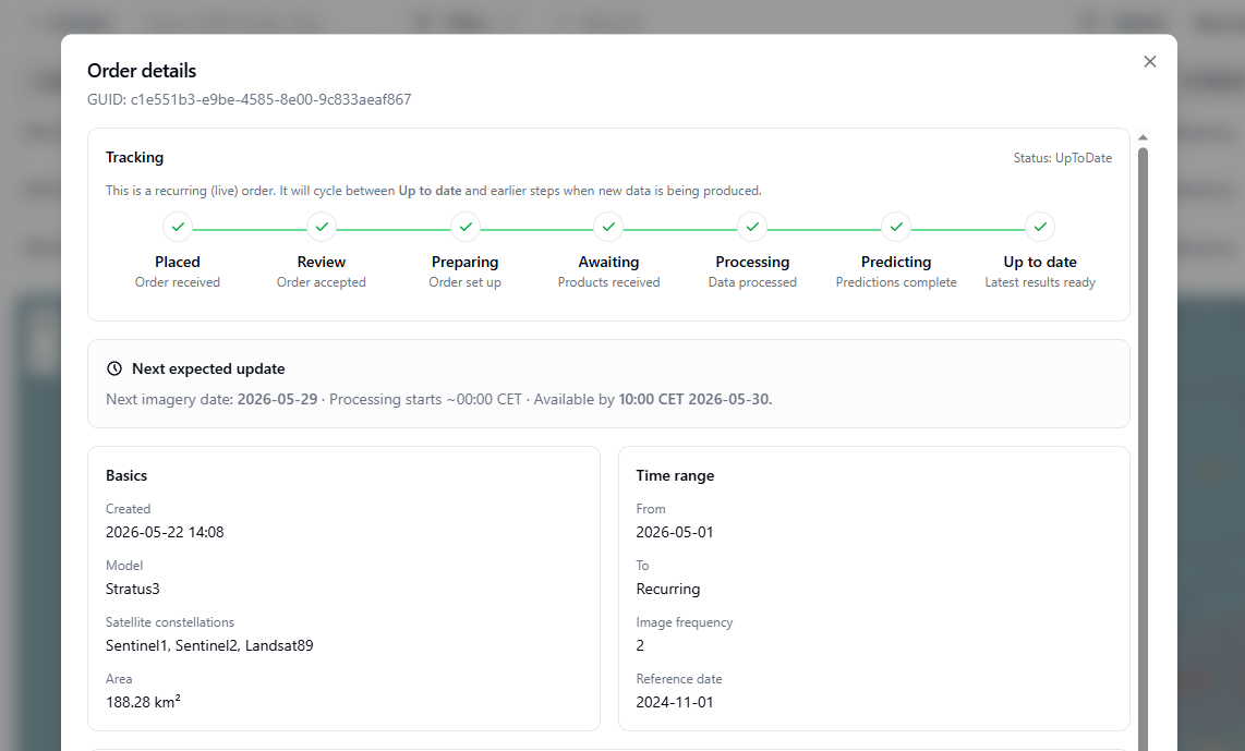
Order details dialog example: live recurring order currently in UpToDate state.
Notes:
- For ProcessingPredicting, both Processing and Predicting are shown as active simultaneously.
- Subtext is written in the correct tense depending on progress (for example, Order accepted after Review is passed, and similar "completed" wording for later steps).
Next expected update (live orders)
Live orders show a Next expected update box. This is an estimate based on:
- Reference date
- Image frequency
In this context:
- Live order: an order with future dates still expected to be produced under the current order settings.
- Recurring orders are always live orders, because they continue into the next month until recurrence is canceled.
If the cadence lands on today, the UI treats today as the next imagery date (so it should be available tomorrow).
Details sections
The dialog also shows:
- Basics: Created, Model, Satellite constellations, Area
- Time range: From/To, Image frequency, Reference date
- Configuration: Storage months, API requests
- Tiles: Only shown when tile IDs exist (with a capped height + scrollbar)
- Geometry / WKT: Copy button and capped height + scrollbar for long geometries
Map preview
At the bottom of the page, a map preview highlights the area for orders that have geometry available.
- Click an area to inspect or reuse the geometry.
- Expired orders may be hidden by default depending on your Map Settings.
This page is designed for managing large order histories. If you have many orders, filtering and hiding columns can improve performance and readability.
For API-based status checks (OrderingProcessStatus) and historical-vs-recurring status interpretation, see Check order status.